|
Flood Hydrologic & Hydraulics
This allows to inventory, view, analyses and exchange of organized, aggregated and processed topographic, geotechnical, geomorphic, hydrologic and hydraulic data employed in contemporary technical flood analysis under FloodSAFE
- Include Hydrologic and hydraulics and Flood mapping data for the SPFC system from CVFED, CVHS, AFED, CSH and CVSS projects including reports and documents produced under FloodSAFE
- Facilitates viewing, access and download tools and models developed and employed in engineering flood analysis for the Sacramento and San Joaquin River Flood Control project under CVFED, CVHS, AFED, CSH & CVSS from FloodSAFE.
CVFED Interactive Map Applications Interactive Map Applications 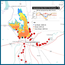
|

.png)